...
| Tool | Category | G | S | I | ||||||||||
With this free smartphone application, collecting your own measurements of salt (EC) and nutrients (nitrate, ammonium, phosphate) in water and of nitrogen levels in soil is a piece of cake. The app makes scans, logs your location and produces results instantly. It is the perfect tool for stakeholder engagement, giving local stakeholders insight by doing their own measurements and at the same time providing a method to build their own database of measurements. The Aquality app can be used with all water samples (surface water, groundwater, drainage water, etc). This way salinisation and nutrients can be mapped and used e.g. to find local 'hotspots' or nutrient losses at the plot level. Creating awareness amongst stakeholders and gaining further insight into the local water system is the first step towards taking the right measures for sustainable fresh water management.
| Stakeholder participation | Design Monitoring Network Fresh Groundwater Resources Zeeland - Technical and geohydrological research Clients: Province of Zeeland and Water Board Scheldestromen Understanding the dynamics of fresh groundwater resources in the Zeeland subsurface is important for sustainable use of these resources. Many new agricultural withdrawals have been added over the past 10 years, but there is no monitoring of whether and what effect this is having on the freshwater lenses. In this project, a monitoring network was designed to monitor fresh groundwater resources. The measurement technique was been worked out based on a so-called 'automatic salt keeper'. This consists of a cable on which there are several electrodes, and a measuring instrument consisting of a sensor/switching module and telemetry. Also a geohydrological survey of potential measurement sites has been conducted. These locations were assessed based on available data of the subsurface, groundwater system and fresh-salt groundwater situation. On top, 53 conductivity probes were conducted as input for the design of the monitoring network. These locations will be equipped with a monitoring well for monitoring the phreatic groundwater level and a salinity probe for measuring at the fresh-salt distribution in the groundwater. The appropriate placement depth of the salinity monitor cable was determined for each location, using a fixed electrode section with as much as 24 electrodes over a total length of 11.5 m (electrode spacing of 0.5 m). | Public results are available through the app or at https://nitrate-app.deltares.nl/ More information: Aquality App: participatory monitoring of fresh and salt | Stakeholder participation | ||||||||||
Deltares can test lock designs in the Lock Facility. It features brine storage and salt mixing tanks, as well as underground reservoirs for storage of salt- and freshwater. The Lock Facility was used to study the flow patterns around the salt screen used to selectively withdraw salt water near the new sea lock in IJmuiden. | Scale model | X | ||||||||||||
Computational Fluid Dynamics (CFD) Computational Fluid Dynamics analyses in salinisation projects are often carried out using Simcenter STAR-CCM+, a commercial CFD based simulation software. STAR-CCM+'s description of the buoyancy-term in the Navier-Stokes equations and k-epsilon turbulence models has been validated by Deltares. Other CFD software packages include D-HYDRO and OpenFOAM but these are used less frequently in salinisation projects | Computational Fluid Dynamics | X | X | |||||||||||
iMOD is freely available and open source software for a wide range of ground water modelling tasks. iMOD consists of user interfaces, pre- and postprocessing software and computational cores based on USGS MODFLOW source code to support analysis of groundwater flow. | Computational Fluid Dynamics | X | ||||||||||||
A wide range of measuring and monitoring techniques is applied at Deltares to gain understanding of the salinity distribution and dynamics in the subsurface and in surface water systems. Our expertise includes survey design (forward modeling), data collection, and processing (inversion, data fusion). Geophysical techniques include:
Environments:
| Airborne Electromagnetic (AEM) geophysical methods Met deze meettechniek wordt met een actief elektromagnetisch (EM) systeem de elektrische geleidbaarheid van de ondergrond bepaald. De uitvoerig vindt plaats vanuit het vliegtuig of de helikopter. Door gebruik te maken van verschillende frequenties kan op verschillende diepten worden gemeten en een geleidbaarheidsprofiel van de bodem worden opgebouwd. Twee specifieke toepassingen zijn HEM (ontwikkeld door BGR, Duitsland) en Sky-Tem (ontwikkeld door Universiteit Aarhus, Denemarken). | Field measurements | X | |||||||||||
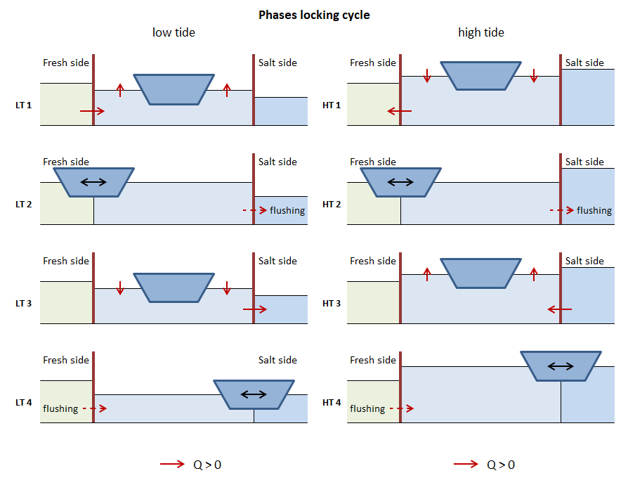
Quick assessment tool to calculate the influence of salt intrusion through shipping locks on the salinity of fresh water, which can for example be used to calculate the salinity at drinking water abstraction points or the salinity of irrigation water. The Sea Lock Formulation is the successor of WANDA-Locks and the Zoutlekmodel (literally: 'salt leakage' model). Previous box-models also included SWINLOCKS. | Quick assessment tool | X | ||||||||||||
...


